Maritime Zones
The article provides a concise overview of territorial waters, archipelagic waters, and the contiguous zone, highlighting their legal definitions, sovereign rights, and implications under international maritime law.;

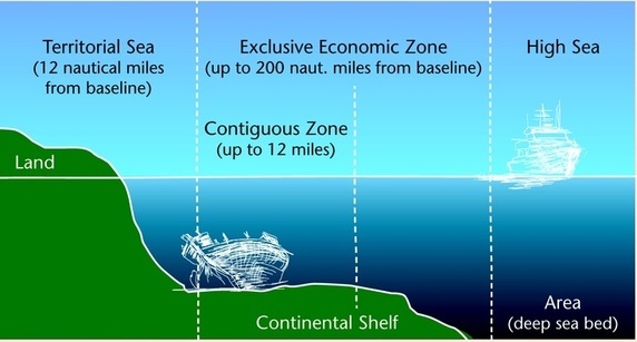
This article on Maritime Zones discusses Territorial Waters, Archipelagic waters, and Contiguous zone. Territorial Waters Out to 12 nautical miles (22 kilometres; 14 miles) from the baseline, the coastal state is free to set laws, regulate the use, and use any resource. Vessels were given the right of innocent passage through any territorial waters, with strategic straits allowing the passage of military craft as transit passage, in that naval vessels, are allowed to maintain postures...
This article on Maritime Zones discusses Territorial Waters, Archipelagic waters, and Contiguous zone.
Territorial Waters
Out to 12 nautical miles (22 kilometres; 14 miles) from the baseline, the coastal state is free to set laws, regulate the use, and use any resource. Vessels were given the right of innocent passage through any territorial waters, with strategic straits allowing the passage of military craft as transit passage, in that naval vessels, are allowed to maintain postures that would be illegal in territorial waters. “Innocent passage” is defined by the convention as passing through waters in an expeditious and continuous manner, which is not “prejudicial to the peace, good order or the security” of the coastal state.
Fishing, polluting, weapons practice, and spying are not “innocent”, and submarines and other underwater vehicles are required to navigate on the surface and to show their flag. Nations can also temporarily suspend innocent passage in specific areas of their territorial seas if doing so is essential for the protection of its security.
Archipelagic waters
The convention set the definition of Archipelagic States in Part IV, which also defines how the state can draw its territorial borders. A baseline is drawn between the outermost points of the outermost islands, subject to these points being sufficiently close to one another. All waters inside this baseline are designated, Archipelagic Waters. The state has full sovereignty over these waters (like internal waters), but foreign vessels have the right of innocent passage through archipelagic waters (like territorial waters).
Contiguous zone
The contiguous zone extends 12 nautical miles beyond the territorial sea baseline, giving a state limited jurisdiction to enforce laws in areas of customs, taxation, immigration, and pollution. This zone allows a state to address infringements that occur within its territory or territorial waters or are anticipated to occur. The contiguous zone also enables the right of hot pursuit, permitting states to chase and apprehend vessels violating laws within their jurisdiction.


